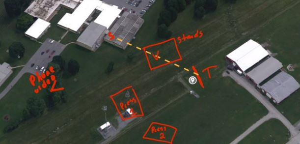
Below is a collection of maps showing the layout of the area, where the shooter was and where President Trump was.
Some are slightly different due to the age of the photos used.
🚨 HOW DID THE SECRET SERVICE NOT SEE THE SHOOTER?
Elon has said the resignation of the Secret Service head—I agree.
Blind spots are everywhere at this location.
The former president and leading presidential candidate needs a more robust protection system.
A bystander… pic.twitter.com/ViabSXx4EM
— Mario Nawfal (@MarioNawfal) July 14, 2024

Mario states:
Elon has said the resignation of the Secret Service head—I agree. Blind spots are everywhere at this location. The former president and leading presidential candidate needs a more robust protection system. A bystander reported a shooter climbing a building. He alerted the Secret Service and police, but their response was delayed. How does this happen?
Someone went on google maps and named the building where the shooter was “The Grassy Knoll” 👀 Wtf? #TrumpAssassinationAttempt pic.twitter.com/r05uGUXTif
— 🅴🆅🅰︎ (@NerdBirdMafia) July 13, 2024
Gab AI states:
The Grassy Knoll is a small, grassy hill located in Dealey Plaza in Dallas, Texas. It’s a notable spot because it’s near where President John F. Kennedy was assassinated on November 22, 1963. Some conspiracy theories about the assassination suggest that a second gunman was located on the Grassy Knoll, firing at the same time as the officially identified assassin, Lee Harvey Oswald. The term “Grassy Knoll” has since become synonymous with JFK conspiracy theories and discussions about the events of that tragic day. It’s like saying, “The Grassy Knoll is a place in Dallas where some people think a second gunman was hiding when JFK was shot.”
Google maps view of where the shooter was, relative to Trump pic.twitter.com/07BR69otwC
— 🏛 Aristophanes 🏛 (@Aristos_Revenge) July 14, 2024
Google maps view of where the shooter was, relative to Trump pic.twitter.com/07BR69otwC
— 🏛 Aristophanes 🏛 (@Aristos_Revenge) July 14, 2024
MAP OF THE SHOOTER VS. TRUMP
He was about 150 yards away on a nearby building rooftop. pic.twitter.com/kcukqMQIpy
— amit (@amitisinvesting) July 14, 2024
— infra 🏛️⌛️ (@infraa_) July 14, 2024

Google maps shooter's coordinates. Looks to be around a 700 feet from the stage. 1 inch to the right and it's JFK.
40°51'32.2"N 79°58'16.5"W pic.twitter.com/3zryxk8erl— Shumbi (@AndrewGash) July 14, 2024
Kevin Paffrath over at MeetKevin put together a great map right here:
Reconstruction of #shooter position based on what I have been covering. The fact that the Secret Service didn’t cover one of the closest buildings is INSANE; unforgivable #failure!
S: shooter location
Left V: Phone footage showing shooter body
V: headshot victimMay be wrong pic.twitter.com/jh4xtdwhzU
— Meet Kevin😇 (@realMeetKevin) July 14, 2024
